Muutke küpsiste eelistusi

Pyrenean Haute Route: The HRP high-level trail 3rd Revised edition [Pehme köide]

  • Formaat: Paperback / softback, 344 pages, kõrgus x laius x paksus: 172x116x19 mm, kaal: 390 g, 66 maps, 60 route profiles, over 100 colour photos
  • Ilmumisaeg: 10-Apr-2024
  • Kirjastus: Cicerone Press
  • ISBN-10: 1852849819
  • ISBN-13: 9781852849818
Teised raamatud teemal:
  • Formaat: Paperback / softback, 344 pages, kõrgus x laius x paksus: 172x116x19 mm, kaal: 390 g, 66 maps, 60 route profiles, over 100 colour photos
  • Ilmumisaeg: 10-Apr-2024
  • Kirjastus: Cicerone Press
  • ISBN-10: 1852849819
  • ISBN-13: 9781852849818
Teised raamatud teemal:

A guidebook for trekking the Pyrenean Haute Route, which zig-zags across the Franco-Spanish border and stays close to the main ridge in the highest and most spectacular central Pyrenees. It covers 800km with a total of 40km ascent, so is only suitable for experienced mountain walkers. The route is split over 45 stages and is largely unwaymarked. This third edition updates 9781852845551 from 2009


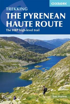
The Pyrenean High-Level Route is probably the most beautiful, spectacular and challenging trek in the Pyrenees. Unlike the GR10 and GR11, the trek from Hendaye to Banyuls-sur-Mer crosses the French Spanish border many times, exploring both sides of the mountain range and staying as close as possible to the main ridge of the Pyrenees. The 800km unwaymarked route is described in 45 day stages, and there are numerous alternative routes that allow you to avoid a difficult section, should weather conditions not be in your favour. The guidebook includes practical information on villages, mountain huts, guesthouses, hotels and campsites, with variant routes and the optional ascents of ten classic summits: Grande Fache, Vignemale, Le Taillon, Pimene, Pic Perdiguere, Pico de Aneto, Montardo d'Aran, Mont Roig, Pic de Certascan and Pica d'Estats.

Preface
Map key
Overview map
Route summary tables

Introduction
The route
Geology
Plants and wildlife
Mountain weather
When to go
Getting there
Accommodation and services
Food, drink and fuel
What to take
Maps
Path conditions
Insurance, mountain safety and rescue
Using this guide

Section 1: Hendaye to Lescun
Day 1 Hendaye to Col de Lizuniaga
Day 2 Col de Lizuniaga to Arizkun
Day 3 Arizkun to Aldudes
Day 4 Aldudes to Roncesvalles
Day 5 Roncesvalles to Egurgui
Day 6 Egurgui to Col Bagargui
Day 7 Col Bagargui to Cabane d'Ardan&##xe9;
Day 8 Cabane d'Ardan&##xe9; to Source de Marmitou
Day 9 Source de Marmitou to Lescun
Variant 1 From Refugi de Belagua to Lescun via La Pierre Saint-Martin

Section 2: Lescun to Gavarnie
Day 10 Lescun to Refuge d'Arlet
Day 11 Refuge d'Arlet to Candanchu
Day 12 Candanchu to Refuge de Pombie
Day 13 Refuge de Pombie to Refuge de Larribet
Day 14 Refuge de Larribet to Refuge Wallon
Variant 2 Refuge d'Arr&##xe9;moulit to Refuge Wallon
Summit 1 Grande Fache (3005m) from Refuge Wallon
Day 15 Refuge Wallon to Refuge de Bayssellance
Summit 2 Vignemale (3298m) from Refuge de Bayssellance
Day 16 Refuge de Bayssellance to Gavarnie
Summit 3 Le Taillon (3144m) from Gavarnie

Section 3: Gavarnie to Salardú
Day 17 Gavarnie to H&##xe9;as
Summit 4 Pim&##xe9;n&##xe9; (2801m) from Refuge des Espuguettes
Day 18 H&##xe9;as to Parz&##xe1;n
Variant 3 Parz&##xe1;n via the high route to Hourquette de H&##xe9;as
Day 19 Parz&##xe1;n to Refugio de Viados
Day 20 Refugio de Viados to Refuge de la Soula
Day 21 Refuge de la Soula to Refuge du Portillon
Day 22 Refuge du Portillon to Refugio de la Renclusa
Summit 5 Pic Perdigu&##xe8;re (3222m) from Portal de Remune
Summit 6 Pico de Aneto (3404m) from Refugio de la Renclusa
Day 23 Refugio de la Renclusa to Hospital de Vielha
Day 24 Hospital de Vielha to Refugi de la Restanca
Day 25 Refugi de la Restanca to Salardú
Summit 7 Montardo d'Aran (2826m) from the Coll de Crestada
Variant 4 Three days on the GR11 from Refugio de Viados to Hospital de
Vielha

Section 4: Salardú to l'Hospitalet-pr&##xe8;s-l'Andorre
Day 26 Salardú to Refugi Gr&##xe0;cia Airoto
Day 27 Refugi Gr&##xe0;cia Airoto to Alós d'Isil
Day 28 Alós d'Isil to Refugi Enric Pujol
Summit 8 Mont Roig (2868m) from Refugi Enric Pujol
Day 29 Refugi Enric Pujol to Refugi de Certascan
Variant 5 To Noarre via Tavascan
Summit 9 Pic de Certascan (2853m) from Coll de Certascan
Day 30 Refugi de Certascan to Refugi de Baborte/del Cinquantenari
Day 31 Refugi de Baborte/del Cinquantenari to Étang de la Soucarrane
Day 32 Étang de la Soucarrane to Refugi de Sorteny
Day 33 Refugi de Sorteny to Refugi de Cabana Sorda
Day 34 Refugi de Cabana Sorda to l'Hospitalet-pr&##xe8;s-l'Andorre

Section 5: L'Hospitalet-pr&##xe8;s-l'Andorre to Banyuls-sur-Mer
Day 35 L'Hospitalet-pr&##xe8;s-l'Andorre to Refuge des B&##xe9;sines
Day 36 Refuge des B&##xe9;sines to Refuge des Bouillouses
Variant 6 GR10 to Refuge des Bouillouses
Day 37 Refuge des Bouillouses to Eyne
Day 38 Eyne to Refugi d'Ull de Ter
Summit 10 Pic des Bastiments (2881m)
Day 39 Refugi d'Ull de Ter to Refuge de Mariailles
Day 40 Refuge de Mariailles to Refuge de Bat&##xe8;re
Variant 7 GR10 to Refuge des Cortalets
Day 41 Refuge de Bat&##xe8;re to Moulin de la Palette
Day 42 Moulin de la Palette to Las Illas
Day 43 Las Illas to Col de l'Ouillat
Day 44 Col de l'Ouillat to Banyuls-sur-Mer

Appendix A Useful contacts
Appendix B Glossary
Appendix C Facilities table
Tom Martens grew up in Belgium and first visited the Pyrenees in 2008 with a friend. This first exploration was so enchanting that he has been back every year since. He has hiked extensively in the national parks and has traversed the whole length of the Pyrenees several times. He also enjoys hiking in Scotland and Estonia, where he currently lives.